Homework will be MATH every night. Check your child's agenda to see which pages are to be completed and returned for the next day.
MATH: We began a new unit on Measurement:
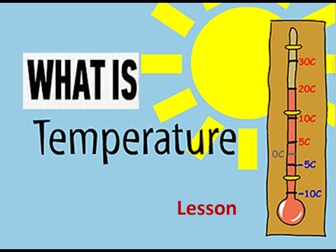
- Part One: Time / Temperature
- Part Two: Mass and Capacity.
The expectations according to the Gr. 2 Ontario Math Curriculum for Part One are students will...
- determine, through investigation, the relationship between days and weeks and between months and years
- tell and write time to the quarter-hour, using demonstration digital and analogue clocks (e.g.,“My clock shows the time recess will start [10:00], and my friend’s clock shows the time recess will end [10:15].”)
- describe how changes in temperature affect everyday experiences (e.g., the choice of clothing to wear)
- use a standard thermometer to determine whether temperature is rising or falling (e.g., the temperature of water, air)

The expectations according to the Gr. 3 Ontario Math Curriculum for Part One are students will...
- solve problems involving the relationships between minutes and hours, hours and days, days and weeks, and weeks and years, using a variety of tools (e.g., clocks, calendars, calculators)
- read time using analogue clocks, to the nearest five minutes, and using digital clocks (e.g., 1:23 means twenty-three minutes after one o’clock), and represent time in 12-hour notation
- estimate, read (i.e., using a thermometer), and record positive temperatures to the nearest degree Celsius (i.e., using a number line; using appropriate notation) (Sample problem: Record the temperature outside each day using a thermometer, and compare your measurements with those reported in the daily news.)
- identify benchmarks for freezing, cold, cool, warm, hot, and boiling temperatures as they relate to water and for cold, cool, warm, and hot temperatures as they relate to air (e.g., water freezes at 0°C; the air temperature on a warm day is about 20°C, but water at 20°C feels cool)

LANGUAGE: We are now turning our writing focus to paragraphs. We are learning how to generate 1 topic sentence, 3-4 detail sentences and 1 closing sentence. Altogether that makes for a 5-6 sentence paragraph. This will be sent home as part of THRoW occasionally, so be on the look out!
SOCIAL STUDIES:
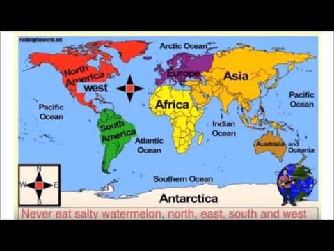
Gr. 2 - Mapping
- demonstrate an understanding that there are a variety of countries, continents, physical features, and bodies of water around the world and that their locations can be represented in different ways (e.g., using globes; print, digital, and/or interactive maps; mapping programs; electronic images)
- identify and label the 7 continents, 5 oceans, the equator, poles, and hemispheres, using a globe, print, digital, or interactive maps, and/or a mapping program
- 3 identify cardinal directions on a map (i.e., N, S, E, W), and use these directions when locating selected communities, countries, and/or continents
- identify the location of selected countries, cities, and/or towns around the world, and describe how their location and climate are related (e.g., Mexico is warm year-round because it is close to the equator; Canada has four seasons because it is far from the equator; Winnipeg is usually colder than Toronto in the winter because it is farther north)
- identify and locate each of Canada's 10 provinces and 3 territories on a map
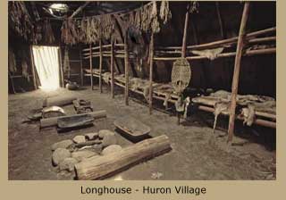
Gr. 3 - Early Settlers of the 1800s
- formulate questions to guide investigations into some of the major challenges facing different groups and communities in Canada from around 1780 to 1850
- identify some of the main factors that helped shape the development of settlements in Canada during this period and describe how the physical features of the land (e.g., topography, proximity to water, fertility of the soil) and the availability of goods and services (e.g., mills, churches, roads) can facilitate settlement and enhance community life
- identify various First Nations and some Métis communities in Upper and Lower Canada from 1780 to 1850, including those living in traditional territory and those who moved or were forced to relocate to new areas in response to European settlement, and locate the areas where they lived, using print, digital, and/or interactive maps or a mapping program
- describe how some different communities in Canada related to each other during this period, with a focus on whether the relationships were characterized by conflict or cooperation
- compare some of the roles of and challenges facing people in Canada around the beginning of the nineteenth century with those in the present day
Ok, that's all for now. I'll post more subject content later!
Coach Wilson
SECRET QUESTION: What are Canada's two official languages?